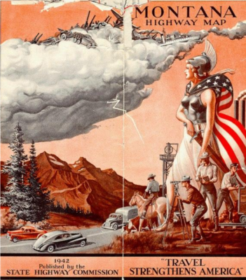
In the American West, history, myth, and landscape are bound together in the formation of a geographical imagination, producing place identities that are deeply entrenched. Place identity is intimately linked to awareness of the past and the construction of heritage. Heritage is constructed and inscribed into place identity via the production of cultural texts, including landscape, literature, popular media, and promotional materials, and, significantly, highway maps.
In this presentation, Rob Briwa introduces the key geographic concepts of place identity, heritage, and critical cartography by examining Montana’s Highway Commission and its Department of Transportation and how it contributes to Montana’s heritage through its highway map program.
Slides from the presentation can be downloaded here (PDF).
Rob Briwa grew up in Pine Bush, New York, at the foot of the Shawangunk Mountains—and through family, teachers, and friends developed an enthusiasm for learning a little bit about everything. As an undergraduate at SUNY Geneseo he pursued this goal through a double major in French and Geography, and was lucky to have the support of mentors in both departments who put up with his eclectic interests and encouraged him to blend his studies in language, literature, and place to pursue scholarship opportunities for study in southern France. These experiences abroad inspired his thesis topic at Kansas State University, where under the guidance of Dr. Kevin Blake he completed a master’s degree in Geography exploring the ways Provençal novelists crafted understandings of what it means to be in Provence. Rob is now pursuing a PhD in Montana State University’s Department of Earth Sciences under the mentorship of Dr. William Wyckoff, his dissertation topic explores the ways that Montana’s state institutions have shaped ideas about Montana’s heritage through landscape and cartography.
Recorded on November 16, 2017 at the Museum of the Rockies.
or Download